 The Cook Islands (Cook Islands Māori: Kūki 'Āirani)[6] is a self-governing island country in the South Pacific Ocean in free association with New Zealand. It comprises 15 islands whose total land area is 240 square kilometres (93 sq mi). The Cook Islands' Exclusive Economic Zone (EEZ) covers 1,960,027 square kilometres (756,771 sq mi) of ocean.[7]
New Zealand is responsible for the Cook Islands' defence and foreign affairs, but these responsibilities are exercised in consultation with the Cook Islands.[8] In recent times, the Cook Islands have adopted an increasingly independent foreign policy.[9] Cook Islanders are citizens of New Zealand, but they also have the status of Cook Islands nationals, which is not given to other New Zealand citizens. The Cook Islands has been an active member of the Pacific Community since 1980.
The Cook Islands' main population centres are on the island of Rarotonga (13,007 in 2016),[10] where there is an international airport. There is also a larger population of Cook Islanders in New Zealand itself: in the 2013 census, 61,839 people said they were Cook Islanders, or of Cook Islands descent.[11]
The latest carbon-dating evidence reveals that the Cook Islands were first settled by around AD 1000 by Polynesian people who are thought to have migrated from Tahiti,[13] an island 1,154 kilometres (717 mi) to the northeast of the main island of Rarotonga.
Spanish ships visited the islands in the 16th century. The first written record came in 1595 when the island of Pukapuka was sighted by Spanish sailor Álvaro de Mendaña de Neira, who gave it the name San Bernardo (Saint Bernard). Pedro Fernandes de Queirós, a Portuguese captain working for the Spanish crown, made the first recorded European landing in the islands when he set foot on Rakahanga in 1606, calling the island Gente Hermosa (Beautiful People).[14]
British navigator Captain James Cook arrived in 1773 and again in 1777[15] giving the island of Manuae the name Hervey Island. The Hervey Islands later came to be applied to the entire southern group. The name "Cook Islands", in honour of Cook, first appeared on a Russian naval chart published in the 1820s.[16]
In 1813 John Williams, a missionary on the Endeavour (not the same ship as Cook's) made the first recorded sighting of Rarotonga.[17] The first recorded landing on Rarotonga by Europeans was in 1814 by the Cumberland; trouble broke out between the sailors and the Islanders and many were killed on both sides.[18] The islands saw no more Europeans until English missionaries arrived in 1821. Christianity quickly took hold in the culture and many islanders are Christians today.
The islands were a popular stop in the 19th century for whaling ships from the United States, Britain and Australia. They visited, from at least 1826, to obtain water, food, and firewood.[19] Their favourite islands were Rarotonga, Aitutaki, Mangaia and Penrhyn.
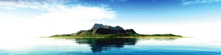
The Cook Islands are in the South Pacific Ocean, northeast of New Zealand, between French Polynesia and American Samoa. There are 15 major islands spread over 2,200,000 km2 (850,000 sq mi) of ocean, divided into two distinct groups: the Southern Cook Islands and the Northern Cook Islands of coral atolls.[32] The islands were formed by volcanic activity; the northern group is older and consists of six atolls, which are sunken volcanoes topped by coral growth. The climate is moderate to tropical. The Cook Islands consist of 15 islands and two reefs. From March to December, the Cook Islands are in the path of tropical cyclones, the most famous of which are Martin and Percy.[33]